障碍物定位
carla 模拟器 给我们与许多更多传感器协作的可能,不仅是一个摄头。 我们可以模拟LIDAR(激光雷达)、IMU(陀螺仪-加速度计-磁力计)、深度传感器、分割传感器......
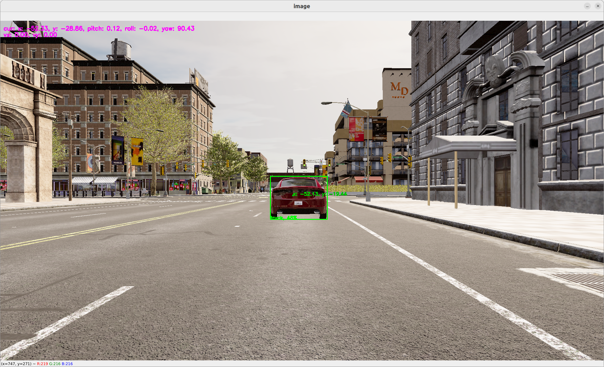
让我们使用激光雷达传感器定位“yolov5”定位的障碍物的确切位置。
雷达点数据是数据点集合,形如
x, y, z, 强度的数组 。坐标基于虚幻引擎坐标系统,即:
- z 是向上
- x 是向前
- y 是向右
更多信息: https://www.techarthub.com/a-practical-guide-to-unreal-engine-4s-coordinate-system/
以及 carla 文档: https://carla.readthedocs.io/en/latest/ref_sensors/#lidar-sensor
您还可以查看 velodyne 参考: https://github.com/ros-drivers/velodyne/blob/master/velodyne_pcl/README.md
为了获得障碍物位置,我们将计算点数据中的每个点的角度。 我们可以将边界框的每个像素的角度映射到一个真实点,从而推断其位置。 我们通过添加 LIDAR 传感器的当前位置,将坐标从相对 lIDAR 坐标系转换为全局坐标系。 代码在此: operators/obstacle_location_op.py.
要使用障碍物位置,只需将其添加到图中,并附上:
nodes:
  - id: oasis_agent
    custom:
      inputs:
        tick: dora/timer/millis/400
      outputs:
        - position
        - speed
        - image
        - objective_waypoints
        - lidar_pc
        - opendrive
      source: shell
      # With Carla_source_node
      args: python3 ../../carla/carla_source_node.py
      #
      # Or with the OASIS AGENT
      #
      # args: >
        # python3 $SIMULATE --output
        # --oasJson --criteriaConfig $CRITERIA
        # --openscenario $XOSC
        # --agent $TEAM_AGENT
        # --agentConfig $TEAM_AGENT_CONF
        # --destination $DESTINATION

  - id: yolov5
    operator:
      outputs:
        - bbox
      inputs:
        image: oasis_agent/image
      python: ../../operators/yolov5_op.py

  - id: obstacle_location_op
    operator:
      outputs:
        - obstacles
      inputs:
        lidar_pc: oasis_agent/lidar_pc
        obstacles_bbox: yolov5/bbox
        position: oasis_agent/position
      python: ../../operators/obstacle_location_op.py

  - id: plot
    operator:
      python: ../../operators/plot.py
      inputs:
        image: oasis_agent/image
        obstacles_bbox: yolov5/bbox
        position: oasis_agent/position
        obstacles: obstacle_location_op/obstacles
要运行:
dora up
dora start graphs/oasis/oasis_agent_obstacle_location.yaml --attach
您应该能够在边界框中看到一个点,表示障碍物全局坐标中的估计位置。
更多信息在
obstacle_location,去至 我们的obstacle_location细节页面